 Castlereagh Nature Reserve is NOT located at Castlereagh Road, Castlereagh, NSW!
http://got2getaway.com.au/tourism/eventdetails.aspx?productid=9085975
Castlereagh Nature Reserve is NOT located at Castlereagh Road, Castlereagh, NSW!http://got2getaway.com.au/tourism/eventdetails.aspx?productid=9085975

1. Cooks River/Castlereagh Ironbark Forest
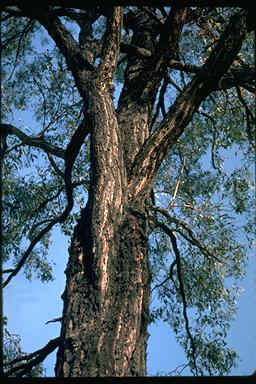 "Cooks River/Castlereagh Ironbark Forest is a community that ranges from open forest to low woodland, with a canopy dominated by broad-leaved ironbark (Eucalyptus fibrosa) (pictured) and paperbark (Melaleuca decora). The canopy may also include other eucalypts such as woolybutt (E. longifolia). The dense shrubby understorey consists of Melaleuca nodosa and peach heath (Lissanthe strigosa), with a range of ‘pea’ flower shrubs, such as Dillwynia tenuifolia, Pultenaea villosa and Daviesia ulicifolia (can be locally abundant). The sparse ground layer is made of grasses and herbs, including kangaroo grass (Themeda australis), weeping meadow grass (Microlaena stipoides var stipoides) and Entolasia stricta."
2. Scribbly Gum Woodland
 Scribbly Gum Woodland is a ecological community dominated by Scribbly Gum (Eucalyptus sclerophylla) (pictured) and Narrow-leaved Apple (Angophora bakeri). Also present are Broad-leaved Ironbark (Eucalyptus fibrosa) and Thin-leaved Stringybark (E. eugenioides). Understory species include Green Spider-flower (Grevillea mucronulata), Needle Bush (Hakea sericea), Slender Tea-tree (Leptospermum trinervium) and Melaleuca nodosa.
" Castlereagh Swamp Woodland is a low woodland community that occurs in poorly drained depressions along intermittent watercourses. Castlereagh Swamp Woodland often has dense stands of paperbark trees (Melaleuca decora) (pictured) along with other canopy trees, such as drooping red gum (Eucalyptus parramattensis ssp parramattensis). The shrub layer is not well developed and is mostly made up of young paperbark trees (Melaleuca decora and M. linariifolia). The ground layer has a diversity of plants that tolerate waterlogged conditions, such as swamp pennywort (Centella asiatica), common rush (Juncus usitatus) and Goodenia paniculata."
Castlereagh Swamp Woodland is listed as an endangered ecological community under the Threatened Species Conservation Act 1995.
Photo: Blacktown City Council Text: NPWS
 "Shale-Gravel Transition Forest is an open forest community. Its canopy is dominated by broad-leaved ironbark (Eucalyptus fibrosa). Other canopy trees include grey box (E. moluccana) and forest red gum (E. tereticornis), which occur less frequently. Paperbark (Melaleuca decora) is common in the small tree layer. The composition of the shrub and understorey varies with the influence of shale or gravel, and often includes blackthorn (Bursaria spinosa), Daviesia ulicifolia, and peach heath (Lissanthe strigosa). Understorey grasses and herbs include kangaroo grass (Themeda australis), weeping meadow grass (Microlaena stipoides var stipoides), whiteroot (Pratia purpurascens) and Australian Bluebell (Wahlenbergia gracilis) (pictured)."


Along the track, at various locations, are signs stating that rehabilitation is occurring, but there aren't any signs of weeding or planting. Perhaps these areas are left to regenerate naturally?

Most trees are relatively young, with dark, rough bark - Broad-leaved Ironbarks (Eucalyptus fibrosa). Many trees also appeared to be blackened by fire. Other trees, like the one pictured below, had smooth, light-coloured bark with noticeable 'scribbles' - Hard-leaved Scribbly Gums (Eucalyptus sclerophylla) and scratches, presumably from Brush-tailed Possums (Trichosurus vulpecula).(


The biggest variation in vegetation composition was the variety of shrubs. The photo below was taken in a particularly verdant patch.


